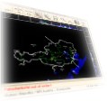
WIIS - Weather Image Information System
A complete solution for the transmission and visualization of weather data like weather radar images, satellite images, prediction data, weather station data, lightning stroke data, wind-profiler data etc.For more information on this product visit our Website www.wetterradar.at (German).

WDMUX - Weather Data Multiplexer
A key building block in designing comprehensive, hierarchical, high-availability weather data networks. The multiplexer software can be used to transmit weather data over a wide variety of transmission links. Different data sources can be assigned with different priorities so that it is ensured that the most important information is transmitted first.SSS - SADIS Server Software.
A software to receive, decode and store meteorological data received from a SADIS station. The software directly interfaces to the SADIS receiver via X.25 and allows to save the data in a variety of different databases.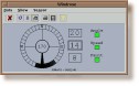
SEDAVIS
Meteorological Sensor Visualization.GTAF
Graphical Metar and TAF Visualization for fast pilot briefing.JEDI
A text editor targetting especially at entering TAFs and METARs.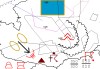
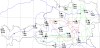
TAUERN AREA
A program for the semi-automatic creation of weather maps. The maps contain tabular data which is automatically requested from a database. Drawing functions can be used to draw arbitrary meteorological symbols on the map.